Dale Matson
Click On Photographs To Enlarge
We drove four and a half hours from Fresno over Tioga Pass
in Yosemite to the White Mountain Ranger Station in Bishop. We picked up our
trail permits for our hike and began the drive to the trailhead (elevation
about 9,800’) in South Lake. Highway 168 is “Line Street” in town and the drive
to South Lake is about 22 miles from Bishop. South Lake Road cuts off Highway
168 and ends at South Lake. The trail to Bishop Pass is popular with lots of
day hikers, fishermen and backpackers. It is interesting to note that Highway
168 is also on the west side of the Sierras and someone probably planned for the
two ends to eventually meet.
The Bishop Pass Trail, once over the pass, continues to
descend and eventually meets the John Muir Trail below Dusy Basin in LeConte
Canyon near the ranger station. There is about 3,000’ of elevation gain from South Lake in the 6 miles to Bishop Pass. There is then a descent into Dusy
Basin. Bishop Pass is the boundary between Inyo and Fresno Counties.
The view from the trailhead parking area is a hint at things
to come. In a sense, this hike reminds me of the hike from the Onion Valley
trailhead for Kearsarge Pass. There are lots of high mountains and small lakes
along the way. The Bishop Pass trail has plenty of places for water resupply.
We talked with a number of groups who made this a four-day/three-night trip.
They stayed at Long Lake the first and third nights and Dusy Basin the second
night.
The outbound trail is well signed but be careful on the
return leg because the sign for the cutoff trail to Chocolate Lakes is high on
a tree and beyond the junction. One could unknowingly find himself headed S.E.
to Chocolate Lakes.
The lakes with easy access are along the west side of the
trail and we took a break at Long Lake. The climb for us was slow partially
because we started our trip that day in Fresno at 5am. There are good
photographs back to the north all the way up but no north view from the pass
itself.
Ben Breaking Camp
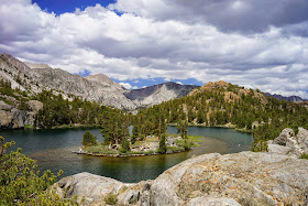
Mt. Goode And Long Lake
Our descent of about 2.5 miles was gradual and we stayed the
night at an established site at about 11,000’ by a stream with a lake view. I would compare our view to the east with
any place I have stayed in Kings Canyon. This is also within Fresno County.
There are lots of 13,000’ plus mountains and North Palisade that is over
14,000’. Ben said there was a little rain during the night with some distant
thunder. It was in the forty-degree range when we awakened, ate and broke camp.
The hike out was not a bad climb for tired legs and it
always amazes me how fresh legs can climb almost as fast as tired legs descend.
We began with cloudless skies with clouds predictably returning in the
afternoon. Our outbound hike time was 5:40 and our return was 5:20. We took
lots of photographs.
On our return we ran into a couple (Tom and Joetta) who had
started in Tuolumne Meadows and been on the JMT for 18 days. They decided to
cut short their hike, turned around before Mather Pass and headed out over
Bishop Pass. We offered them a ride back to Tuolumne and they gladly accepted.
Good timing folks! We saw them turn into the store area and I just know they
were headed for the hamburgers and fries. I've been known to do that myself
after being on the trail for spell.
Note: A video with more graphics is available here:
https://www.youtube.com/watch?v=acPx5Fhx_2c&feature=youtu.be
Note: A video with more graphics is available here:
https://www.youtube.com/watch?v=acPx5Fhx_2c&feature=youtu.be


No comments:
Post a Comment