Dale Matson
Click On Photographs To Enlarge
This is really an ‘unofficial’ hike with no trails along the
Madera County side of Millerton Lake in the area I hiked. There is an area to park across the road
from where you begin. My hike began on the paved, steep and gated service road
just before the boat ramp. The road initially climbs to a fenced water tank
utility area. My hike was about 2.5 miles round trip with 840’ of ascent. The highest
point was 1,102’ in elevation. This was a slow 3-hour hike with lots of ups and
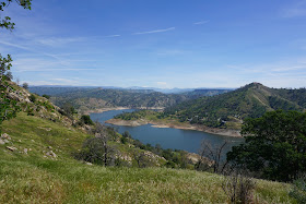
downs with good views of the lake. The lake is very low, having been
intentionally lowered to make room for the snowmelt in the spring. There has
been about 500” of snowfall above 9,000’ in the Sierra thus season with more expected. Millerton Lake is fed
primarily by surrounding runoff and the San Joaquin River, which should be
quite a raging torrent once the three branches merge above Mammoth Pool
reservoir. The grass has grown to above knee height in many places, which
slowed down my walking. There were no bugs and no water available for purified
resupply.
I was trying out my new Sony A6000 (APS-C sensor) camera
with the kit 16-50mm lens. Sony also has a “clear zoom” feature that allows an
additional digital zoom that doubles the optical 50mm to 100mm. Although I was
amazed at the photo IQ of this camera and lens combination, the clear zoom
seemed to suck the color and life out of the photographs where I used it. I
restored some of the color in Photoshop but don’t recommend the clear zoom
unless a particular feature needs to appear larger. I ordered a used Sony/Zeiss
16-70mm f4 lens, which has a good reputation and will replace my kit lens when
it arrives. It won’t add a lot of weight but will improve reach and photo quality.
I had taken a similar hike but shorter route previously and
took some shots with my Canon 400mm f4 lens. It was a terrible day for
photographs on the earlier hike but I saved three shots so I could include them
with this longer hike.
Friant Dam At Top Of Photograph With Low Waterline
Mckenzie Lava Table Top Right
Quite A Bit Of Dry Lake Bed Here
Millerton Lake Begins Bend Around Pincushion Mountain
Mountains With Snow At Top Of Photograph
Pincushion Mountain 100mm
Lava Table Above Sky Harbor Road
My Vehicle Below
Winchell Cove Marina
Winchell Point
Hikers On Top Of Pincushion Mountain 400mm
Western Bluebird


No comments:
Post a Comment