Dale Matson
Click On Photographs To Enlarge
Two of the major rivers of western slopes of the Central
Sierra Nevada watershed are the San Joaquin River and to the south, the Kings
River. I have devoted a considerable amount of time and space to the San Joaquin
and nearly nothing on the Kings River. It, like the San Joaquin has a north,
middle and south fork with headwaters in the high sierra. Actually, the Middle
Fork of the Kings and the South fork of the San Joaquin have headwaters less
than five miles apart. The Middle Fork of the Kings River begins at Helen Lake
in Evolution Basin in Kings Canyon Park. I have walked along it in LeConte
Canyon as it travels along the JMT. The South Fork of the San Joaquin begins in
Goddard Canyon at Martha Lake in Kings Canyon Park.
I have crossed three of the major tributary streams for the
Kings; Bubb’s Creek, Woods Creek and Dinkey Creek. All three are really rivers
after heavy snow years like this winter. Dinkey and Woods have bridges but
Bubb’s does not and it can be very dangerous to ford. The JMT crosses Woods
Creek via a suspension bridge that only accommodates one person at a time.
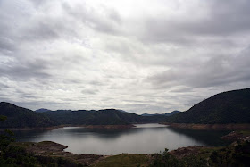
As you will see in the photographs, Pine Flat Lake is only
about 50 percent of its one million acre foot capacity and is being emptied to
make room for the expected massive snow melt this year. The dam was completed in 1954, is 20 miles long and has 67 miles of shoreline. In addition to irrigation, recreation and electricity generation, Pine Flat also was built for flood control.
It was a drizzly overcast day but I enjoyed the vast expanse
of beauty before me. The foothills are still green with splashes of
wildflowers. I used four lenses on my Sony A7R2 since I was driving along the
river in my truck on Trimmer Springs Road and not backpacking the weight.
I used my Sony A7R2 and an adapted Canon 70-200 2.8, an
adapted Leica Elmarit 28mm 2.8, a Batis 18mm 2.8 and 85mm 1.8. The wider lenses
were more useful. Both the Leica and 18mm Batis have wonderful color.
I have a short YouTube slide show of the photographs with
included video clips here: https://www.youtube.com/watch?v=4D5h6BfAaOE


No comments:
Post a Comment