Dale Matson
Click On Photographs To Enlarge
Ambit 3 Route
Garmin Map 64 Route
This is about an 11-mile round trip
hike with about 3,000 of gain to 10,200’. If you have already hiked the more
popular route along the north fork of Big Pine Creek, this is another route
that will take you to a view of the Middle Palisade and Clyde Glaciers as you
approach Brainerd Lake. The north fork takes you to a view of the bigger
Palisade Glacier. Most of the hike is a good trail except for the many
switchbacks that ascend over 1,000’.
This trail is accessed out of the
town of Big Pine (14 mile south of Bishop CA). Turn west on Crocker Street which becomes Glacier
Lodge Road. Take this road to the end unless you are backpacking. There is a
place before this for backpackers to park before you get to the stables. I paid
a small parking fee and parked near the Glacier Lodge store. I got a late start
and began the route incorrectly. I waded across the south fork and began
climbing the road. I had not taken the proper route that crossed the bridge at “First
Falls”. Fortunately, I noticed the sign indicating the south fork trail. It was
probably a shortcut of sorts if you didn’t mind wet feet.
There is a place along the trail
where you will cross the creek from the north to the south side. Go to where the
trail ends on the north side and cross there. You may get wet feet! It is also
a good place to resupply water if you have a means to purify or filter it. I'm not sure this part can be crossed earlier in the year. It
seems as if the switchbacks will never end and you cross some boulder fields.
As you look back you begin to see the yellow fall colors begin to appear.
Once you finally top out from the
climb, the Glaciers begin to appear along with Middle Palisade, Clyde Peak, The
Thumb to the west and possibly Disappointment Peak and Mt. Jepson to the north.
As you continue, you will pass a junction sign that will indicate a trail to
Willow Lake. Some camp here overnight and continue the next day. Willow Lake
can be seen from above later on the Brainerd Lake Trail.
The trail becomes less clear the
closer you get to the lake so pay attention. You will cross a small creek on
two logs which is also another place for water resupply until you get to the
lake. Also, you will pass a muddy pond prior to Brainerd lake. Brainerd Lake,
is quite green. This is caused by glacial silt runoff. This is a similar color
to the green lakes on the north fork of Big Pine Creek.
I had considered climbing from
Brainerd Lake up to Finger Lake (another 600’) which is a wonderful view but it
is a steep climb with no trail. I was already tired from my late start. I
actually drove from my home in Fresno that morning! I didn’t get back to my
truck till nearly 7pm and slept in my truck till morning. I also had to take a 40-minute
nap by Tenaya Lake on the way home.
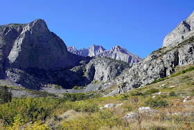
Birch Mountain Left Middle Palisade Glacier Right
View From Glacier Lodge Area
Don't Take This Road
If You Do, You Will Have To Wade This
Stream Crossing
Mt. Jepson Right and Palisade Crest Left
Stream Crossing
Willow Lake
Brainerd Lake
Mule Dear
Middle Palisade Glacier Left and Clyde Glacier Right
My video of this hike can be found here: https://www.youtube.com/watch?v=bXZMSCPrITs&feature=youtu.be


No comments:
Post a Comment