Translate

Monday, July 31, 2017

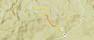
Hike Above College Rock Toward Kaiser Peak


Dale Matson

Click On Photographs To Enlarge
Hike Route
As Dirty Harry once said, “Every man has to know his limitations.” I seems the older I get, the more I have to relearn and adjust downwards, those limitations. Here is last years trip to the top. http://midsierramusing.blogspot.com/2016/07/kaiser-peak-hike-2016.html
I got an early start (6am) and hoped to get at least to a point on the trail where I had a good view of the Central Sierra Nevada. And, that is as far as I got. It was a little over 8,900’ when I turned back. Kaiser Peak is about 10,300’. It was 4.5 hours up and 3 hours down total time out. The trailhead temperature was 50 degrees to start and 80 degrees at the end! That is pretty hot for 7,000’ in altitude. I was tired and the 1.5-hour drive back down to Fresno was not easy either.
Anyway, I thought I would share some photographs I took this year with my Sony A6000 and S/Z 16-70mm lens. They are less than optimal because there is considerable issues because of a forest fire that started near Mariposa and is still not contained. I wanted to travel as light as possible and used my Mountain Hardwear Race Vest as a daypack. Here is a photograph of me with it on at Devil’s Bathtub near Edison Lake. http://midsierramusing.blogspot.com/2014/06/a-race-vest-as-day-pack.html

I started with one full bottle of water and resupplied in the creek in a meadow above College Rock on the way up and on the way down. I suspect that there will be no water available for the entire hike by mid August. If you do the hike then, you will need to carry about three liters of water with you.

 Early Morning D&F Pack Station


 China Peak Ski Area
 Fading Snow Plant
 Huntington Lake Full Of Water


 Mama Grouse
 Grouse Chick
 The Steep Climb Above The Meadow
 Trail Leading To Next False Summit


 Banner Peak Near Mammoth CA


 Edison Lake Center Below Vermillion Cliffs


 George Lake You Can Get There Via The Twin Lakes Trail
https://midsierramusing.blogspot.com/2013/08/potter-pass.html


 Mt Goddard Center


Ubiquitous Marmots

Wednesday, July 26, 2017

Coronary Artery Disease, Stents and Improving Maximum Heart Rate


Dale Matson

I previously wrote an article, which may serve as a useful introduction: http://sanjoaquinsoundings.blogspot.com/2017/03/cardiac-stents-dual-antiplatelet.html
I believe there is a lack of understanding in the scientific literature on the extent of the personal devastation brought about by a diagnosis of Coronary Artery Disease (CAD). This is especially true of those like myself who have led competitive and active lives. Much of our lifestyles and even identities are based on being active. The grief, anxiety and occasional depression are difficult to live with especially since there is little good guidance available that can cushion the devastating diagnosis with hope for the future. My following comments are as an individual lay person and I do not recommend anything I have done for anyone else without that person first consulting with their medical specialists. However, I have found my primary care physician to be invaluable as a consultant and for looking at the overall picture. He has also been encouraging.
Yes, there are good recommendations on diet and food, which can be more than fuel. Food can be medicine. I am not convinced by personal research that the usual protocol cocktail of statins, blood pressure medications, and blood thinners save or even prolong lives. For me, it always seems to come down to the fine line between living the most ‘risk free’ life and a quality life. Additionally some measures and medicines may actually endanger lives with bleeding and anemia.
The most important number to me is not my cholesterol LDL or other measures. It is my Safe Maximum Heart Rate. My Maximum heart rate of 110 was set by my cardiologist following my treadmill stress test, which indicated Ischemia even thought I reached the maximum predicted heart rate of 148 (I am 72 years old)
I wanted a definitive test and we decided on an angiogram, which resulted in having drug-eluting stents implanted. Within two weeks I had a severe bleed resulting from the combination of dual antiplatelet therapy (DAT) (Plavix and aspirin) and undiagnosed ulcers. The GI doctor was able to stop the bleeding with hemoglobin of 7 and with antacids was able to keep me from a reoccurrence. He did caution me that I could bleed again.
The long road back began with the anxiety of another possible bleed or a thrombosis in my stents caused by a clot if I stopped the DAT. This anxiety has been severe enough for me to have ‘as needed’ Xanax prescribed by my primary care physician. I believe it has kept me out of the emergency room more than once.
Three Variables I can control
1. Since the stents were inserted, I have lost 17 pounds. I now weigh less than when I completed Hawaii Ironman and the Western States 100 mile endurance run.
2. I continue to build my iron levels with an iron rich diet and iron supplements. My current hemoglobin is up to 12.8 but not optimal. I hope to raise my hemoglobin to about 16. This will allow better oxygen availability.
3.  I intend to incrementally increase the intensity and duration of my exercise to strengthen my heart. This includes cycling, swimming, walking, and weight training. I can do this because I have a “new” maximum heart rate of 120bpm to work with. The cautionary low heart rate guidelines I have been using have actually ‘detrained’ my heart. Much of my exercise will be in the Sierra Nevada Mountains so there will be additional acclimatization. All of this is done wearing a Suunto heart monitor and chest transmitter. I also keep careful records.
            I have places in the mountains I want to get to and photograph. Each place is progressively more difficult with the final destination requiring four days and three nights of backpacking. Of course this is all predicated on discipline, patience and knowing when to back off if necessary. My next scheduled appointment with my cardiologist is set for January of 2018. I don’t think of this as “heart rehabilitation”. I think of it as I have thought about it for the last 30 years, “Training”. I hope this makes sense to others out there like me.  

Monday, July 24, 2017

2017 Hike From Badger Flat To Potter Pass And Twin Lakes


Dale Matson

Click On Photographs To Enlarge
Hike Route Off Kaiser Pass Road 

This is one of my annual “warm up” hikes and previous reports can be found here:
What is different this year is the much later date of the hike. July 16th is more than a month later than usual because of the heavy snowfall this past winter. Even as this is posted, this is the most snow I have seen on and along the trail.
I have mentioned previously that the hardest part of this hike (with a total gain of about 1,500’) is the 400’climb inbound back up to Potter Pass from below the meadow area. Your legs are not fresh and the climb is steep and exposed. The trail is well marked but keep an eye on the signage. The trail to George Lake from Upper Twin Lake, for those going further, is not as obvious.
We did this hike on a Saturday so the trail traffic was higher than a weekday. We actually met 8 folks along the way that we knew. It is a popular hike for those from Fresno, CA. We also passed several backpackers who had overnighted at Upper Twin Lake.
It has been hot with triple digit temperatures in Fresno. Our early start at the 8,300’ trailhead was about 50 degrees with a finish temperature of 80 degrees. The trailhead is across the highway from the parking area. There are toilets there also. This year, there were lots of mosquitos and we passed a couple of folks who had unfortunately turned around prematurely at Lower Twin Lake discouraged by the mosquitos. There is a seasonal pond between Lower and Upper Twin Lakes that serves as breeding habitat for the mosquitos. We found a nice location at Upper Twin Lake for morning snacks and Sharon’s annual swim that had few mosquitos.
I was traveling lighter this year and the photographs are with the Sony A6000 and Sony/Zeiss 16-70mm f4 lens. We had about the same total time out this year as last year of about 5.5 hours. My heart rate data confirms that the climb out inbound is the most strenuous. There are nice “sitting rocks” at Potter Pass where you can admire the view of the Sierra Nevada Mountains near Mammoth CA. It is also a trail junction with those taking the Potter Pass Cut Off Trail which begins lower on Kaiser Pass Road. There is also a section of the trail where you can see Mammoth Mountain above and behind the meadow area as you walk the trail.
This year, we also had the Detwiler Fire smoke to contend with. This wildfire that began near Mariposa is only 40 percent contained and has already destroyed 76, 000 acres as of this date. The U.S. Forest Service folks have already cleared the trail of winter deadfalls.


 Snow Plant

 China Peak Ski Area


 Sierra Nevada View At Potter Pass


 Sample Meadow Is North East Of Kaiser Pass

 Banner Peak And Mt. Ritter Center Left

 Lower Twin Lake

 Mosquito Breeding Area Between Lakes
 Upper Twin Lake


 Annual Swim

 Mammoth Mountain Center


Huntington Lake (Elevation 7,200')