Translate

Wednesday, June 30, 2021

Kaiser Peak Hike 2021


Dale Matson

Click On Photographs To Enlarge


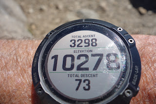
Kaiser Peak (10,300’) is my annual penultimate hike on the west side of the Sierra Nevada before I take on more difficult hiking and backpacking on the east side of the Sierra. This year was the first year I was able to see first-hand some of the fire damage from the monstrous Creek Fire. The Kaiser 17-mile Kaiser Loop trail is closed but that hike includes a more westerly section that was hard hit by fire. I took the shorter and my traditional trailhead route for me which heads due north from above the D&F Pack Station (Upper Deer Creek Lane) off Huntington Lake Road. Although there was evidence of spot fires lower down, there was no evidence of fire about 9,000’. There is much less vegetation than to the West. The trail is in good condition with only one tree to have to go around.

The weather has been hot and I assumed there would be no water resupply opportunities by now with a low snow year so I packed in about 3 liters of water in my day pack and got an early start and began my hike about 5am (start temperature 45degrees). The air was relatively clear. It is always good to get an early start because thunder storms can pop up in the afternoons. The Sierra makes its own weather.

Based on years of experience I would measure the round-trip distance as eleven miles with about 3,300’ of gain. I would classify this as a strenuous hike. I was out about 7.5 hours and traveled at my old man (76) pace. It was a double test since Sharon and I did the Twin Lakes trail with friends two days later.

First Rest Stop
College Rock About Half Way

Banner Peak Background


Mammoth Pool Reservoir Center Bottom
Central Sierra


Saturday, June 26, 2021

Twin Lakes 2021


Dale Matson

Click On Photographs To Enlarge

Trip Route

Distance 7.5 miles round trip from the Badger Flat parking area.

About 1,500’ of altitude gain. Top Elevation is Potter Pass at 9,000’

Lots of mosquitoes. Bring water but there is dependable treatable water at both lakes. We were out for about 5.5 hours total. I would rate this hike moderate. It is more popular this year since some of the trails in the Sierra National Forest have been closed due to last year’s Creek Fire damage. Nearby trails that are closed include the Kaiser Loop Trail and the Nellie Lake Trail. The most noticeable fire damage was near Cressman Road and Tamarack Ridge. It is also bad near Billy Creek Campground.

This was a trip with Sharon and Hobbes plus trail companions Terry and Chanda. They are a decade younger and fit. We could not keep their pace. Hobbes (aka trail ambassador) went about 25 miles and insisted on greeting everyone we passed on the trail including a group of four on horseback. We held him as the riders passed by. 

The climb to Potter Pass from the trailhead is gentle for the 2.2 miles. It is at Potter Pass that you enter the Kaiser Wilderness. It is actually the climb back up to Potter Pass from the lakes that is steeper and more difficult. 

Sharon did her usual swim around the island at Upper Twin Lake and this year she had company with Terry and Chanda. Hobbes and I stayed on shore.

I would recommend an early start. We met at 7am and were glad to be headed back before the hottest part of the day.  


Lower Twin Lake


Wednesday, June 16, 2021

Dinkey Lakes - Mystery and Swede Lakes only


Dale Matson

Click On Photographs To Enlarge

Hike Route

Moderate out and back

Distance 5.0 miles (the full loop and all 4 lakes is about 8 miles.)

Maximum elevation 9,200’. About 800’ of gain overall

5 hours (Sharon and I were both taking photos and she and Hobbes went for a swim. We are also old.

This hike is about 2 hours from Fresno. Head east on Highway 168 to Shaver Lake, turn Right on Dinkey Creek Road, Turn left on to Rock Creek Road from Dinkey Creek Road. It is a 12-mile drive to the trailhead. The first 6 miles is lousy and the next 6 miles is even worse. The bridge over Cow Creek has been replaced. A 4X4 is not necessary but high vehicle clearance is necessary and good tires. There is an excellent Tom Harrison map of the Dinkey Lakes Wilderness area. 

Although this is the third time I have visited the Dinkey Lakes area in the Dinkey Lakes Wilderness, it is my first report. Much of the trail follows water and swamp. Our dog had plenty to drink. This hike had the most mosquitoes of any hike we have done this year. For Sierra National Forest hikes, I would rate it as one of the best. Follow the trail signs! There is no toilet at the trailhead. I didn’t use my trekking poles for most of the trail but there are places on the climbs and descents where I did use them. There are campsites on the lakes but overnight permits are required through Recreation.Gov.

I used my new Sony A7C camera and the newer Sony 24mm 2.8 lens for the photos. I was pleased by the results. It is nice to have a camera with image stabilization and other new features in a body that is the weight of my old A7.


Mystery Lake


Swede Lake

Hobbes swimming out to Sharon