Dale Matson
About 35-40 Miles Round Trip From Onion Valley
About 35-40 Miles Round Trip From Onion Valley
Click On Photographs To Enlarge
60 Lake Basin is a less accessible and thus less popular
destination than the Rae Lakes Basin which is adjacent to it to the east. The
entry point via a trail is off the John Muir Trail at the southern end of Rae
Lakes. The most direct but brutal access route is over Baxter Pass from the
town of Independence off Highway 395.
This is an area where the Mt. Baxter unit
of Sierra Nevada Bighorn Sheep may be spotted. This is not a well-used or
maintained trail however. After reaching the pass, the trail descends past
Baxter Lake to meet the John Muir Trail at the north end of Rae lakes Basin
just north of Dollar Lake. I guarantee you that there is absolutely no trail
that you can see leading away from the Baxter Pass trail junction sign on the
JMT. From there, the trail to 60 Lake Basin is south on the JMT to the Junction
where the sign indicates the trail.
The Sign Means What It Says
I suppose if one were traveling north or south on the JMT,
one could visit 60 Lake Basin as a side trip but for me, the best route from
where I live in Fresno is to Come over Tehachapi Pass east of Bakersfield and
come north to the town of Lone Pine. I pick up my wilderness permit at the
Visitor’s center and head to the trailhead at Onion Valley. From there I climb
over Kearsarge Pass and take the northern route that meets the JMT. It is also
possible to spot Bighorn sheep in this area since the Mt. Baxter herd can be
found this far south. Once you join the northbound JMT, you go over Glen Pass
and shortly after you reach Rae Lakes, you will see the trail sign indication
60 Lake Basin.
There are some nice established campsites soon after you
turn off the JMT with access to and slightly above Rae Lakes. There is a two-night
limit for camping at Rae Lakes and I think this area would not be strictly
considered “Rae Lakes”. From here I have done two day trips into 60 Lakes
Basin. Rae Lakes and 60 Lakes are also ‘hotspots’ for seeing the endangered
Bighorn Sheep.
There is an initial climb on the trail to 60 Lake Basin
which takes you over 11,200’ of elevation. As you pass a small lake, the trail
begins to top out and then descend to the basin. Actually Rae Lakes and 60
Lakes are similar elevations running in parallel with a ridge in between the
two of them. As I descended to the basin near a sign that states, “No stock
beyond this point”, I saw two bighorn sheep but they ran off above me before I
could photograph them.
On this two night three day trip, my intent on my day trip (2nd day) was to get to Gardiner Basin and
in a sense; I was just passing through the basin. The trail through the basin
initially travels west-northwest and then north. At the point the trail heads
north, I left the trail heading southwest around the north end of Lake 3304
(also called Long Lake by some). From there I began to climb off trail
traversing toward Cotter Col. which is a gap in a ridgeline descending south
from Mt. Cotter (12,713’). It is a difficult climb and I didn’t pick the best
route outbound. From Cotter Col, one can see into Gardiner Basin. I had seen
all I wanted to see for that 2nd attempt and headed back to my tent
near Rae Lakes.
On my return, I followed the trail north for a time but it
soon becomes a maze of smaller use trails and is no longer dependable as a trail.
I needed to use “Track Back” on my GPS to find and retrace my steps to a more
dependable part of the trail back to the Rae Lakes Area.
Trailhead At Onion Valley
Kearsarge Pass
Upper Trail Joins Northbound JMT
Kearsarge Pinacles And Kearsarge Lakes
Bullfrog Lake From Trail With East Vidette On Far Left
Charlotte Dome Telephoto
Glenn Pass Looking North Toward Rae Lakes
Camp Near JMT Trail Junction With 60 Lake Basin
Painted Lady Above Right
First Lake On Climb Up 60 Lake Basin Trail
Looking Down On Rae Lakes From 60 Lake Trail
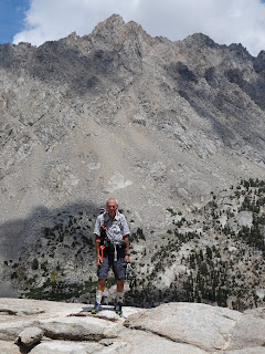
Author
One Of The Lakes In 60 Lake Basin
Mt Clarence King
Long Lake And West Side Of Fin Dome
Mt. Clarence King
Off Trail Climb To Cotter Col
Mt. Cotter And Gardiner Basin
Looking North In Gardiner Basin


No comments:
Post a Comment