Dale Matson
This hike is not to be
confused with the “Devil’s Bathtub” in Yosemite.

The hike is about 10 miles
round trip in the Ansel Adams Wilderness of the Sierra National Forest with about 1,600’ of altitude gain outbound. The altitude of Devil’s
Bathtub is about 9,200’. It is about 2.5 hours up and 2 hours back down hiking
time.
Ok, so some of these hikes take longer to get to and home
again than the actual hike. We set out from Fresno at 6am and arrived at Edison
Lake at 9am. The final hour was brutal and is only about 14 miles. The fresh
asphalt patches (on patches) on a narrow one-lane road made a slow go of it. I
suppose it would have been better with a vehicle with softer suspension. The
view of the central Sierras was splendid but I was the driver and had to keep
my eyes on the road. Meeting another vehicle can be a bit of a challenge if
neither has the room to pull over and someone has to back up. There is a sign
by the resort that says, “Freeway ends one half mile” (Not really funny at
that point).
After passing the Vermilion Valley Resort (“VVR” on the
signs), we continued to the parking area for the trailhead. As we headed out,
we ran into U.S. Forest Service workers who had been assigned to clear the
deadfalls from the trails. The young ladies with us said some of the trail
workers looked like “Hipsters”, whatever that is.


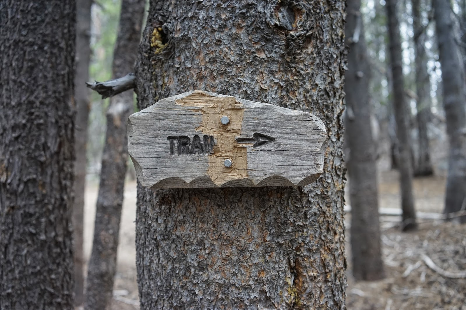
Follow The Arrow On This Sign

Follow This Sign

Panorama Of Devil's Bathtub
The Tom Harrison Map puts the trail junction for heading
north to Devil’s Bathtub at about 2.5 miles but my GPS had it further along.
The reason I say this is the sign that reads, “Trail” with an arrow pointing to
the right at what looks like where you head north but that is too soon. Follow the signs. Keep going in the
direction the sign is pointing. The trail at what appears to be a junction heading
north only goes to a campsite. You will come to a sign that indicates the place
to head north for Devil’s Bathtub.

The final portion of the hike is mostly climbing but it is
not bad if you are fit and traveling light. Most of the hike is in the woods
and things did not open up until we reached the lake. We reached the lake at
about 5 miles on my GPS. It is a splendid sight and secluded in a bowl with
mountains to the north. The water temperature near shore was about 60 degrees
and two brave souls decided to jump in.
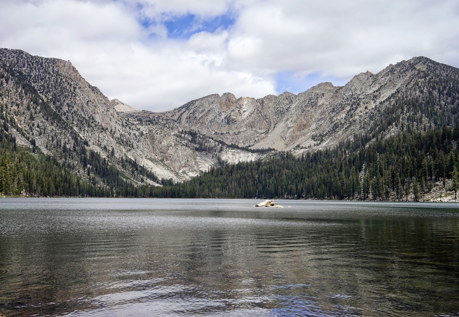
Graveyard Peak On Right And Silver Peak Center
The return hike is easy and goes fast. It was nice to stop in
the VVR and buy some well-earned treats for the trip home. Some of the PCT thru
hikers were there to pick up supplies mailed there earlier and clean off some of the trail dirt in the available showers. Most of the JMT
folks resupply near Florence Lake at Muir Camp. When you are driving back
toward Kaiser Pass the area you hiked to can be seen quite clearly but the lake is hidden
in the bowl. This is a tough drive but a sweet hike.
Dale (Trail name “Padre”)
Click on photographs to enlarge
ReplyDeleteI love this hike! It's a tough one for me as I'm usually carrying a 40-45 pound backpack. I love the far end of the lake, where the sandy shore is. It is another 3/4 of a mile or so, over boulders, but so worth it. The setting the lake is in, is such a beautiful place.
ReplyDeleteWhich way do you hike around it? Do you go left or right?
DeleteI have just been told, (Aug. 2017) that this road up to Mono Hot Springs is so bad that you need a jeep or truck. This guy who had been there, at some time in the past) said there were deep ruts and holes, and his friend who drove it in a car had his oil pan ripped off. Perhaps the road has been paved or graded? Can anybody report on its current condition? I need to drive up this road in a car in Sept. 2017. Is this possible now?
ReplyDeleteI do not recommend using a low clearance vehicle. I have no idea how good the road is after a record snowfall winter. Some of the roads like Dinkey Creek Road were closed for repairs after being washed out this spring.
DeleteI just drive this road Sunday August 19, 2017, in a 2017 Subaru Crosstrek small SUV. The road surface was not bad but encountering vehicles coming the other way where there's no room has always been vexing the 40 years I've driven this road.
ReplyDeletePeople are generally civil about moving into a wide spot up or downhill. I get nervous when a vehicle pulling a boat or trailer has to stop. It is very difficult for them to back up and they have a lot less room to get out of the way.
DeleteKaiser Pass Road remains closed as of May 1st.
ReplyDeleteI have driven it in a Honda Odyssey. It wasn't too bad. Beautiful drive but go earlier for less people on the road.
ReplyDeleteWe just did it in an Odyssey (today) as well! My kids were very concerned about having to drive out on that road for our whole camping trip. It was slow going, but people were pretty considerate. It was much easier on the way down when we knew what to expect (and it was at the beginning of a 6 hour drive instead of the end.
DeleteJust follow the signs.
ReplyDeleteKaiser Pass road is open and has been open for at least 2 weeks. I don't know what shape the road is in to Edison and Florence Lakes
ReplyDelete