Translate

Friday, July 29, 2022

When Poor Sleep Means Poor Recovery? The Garmin Fenix 7X Solar

When Poor Sleep Means Poor Recovery? The Garmin Fenix 7X Solar

Dale Matson

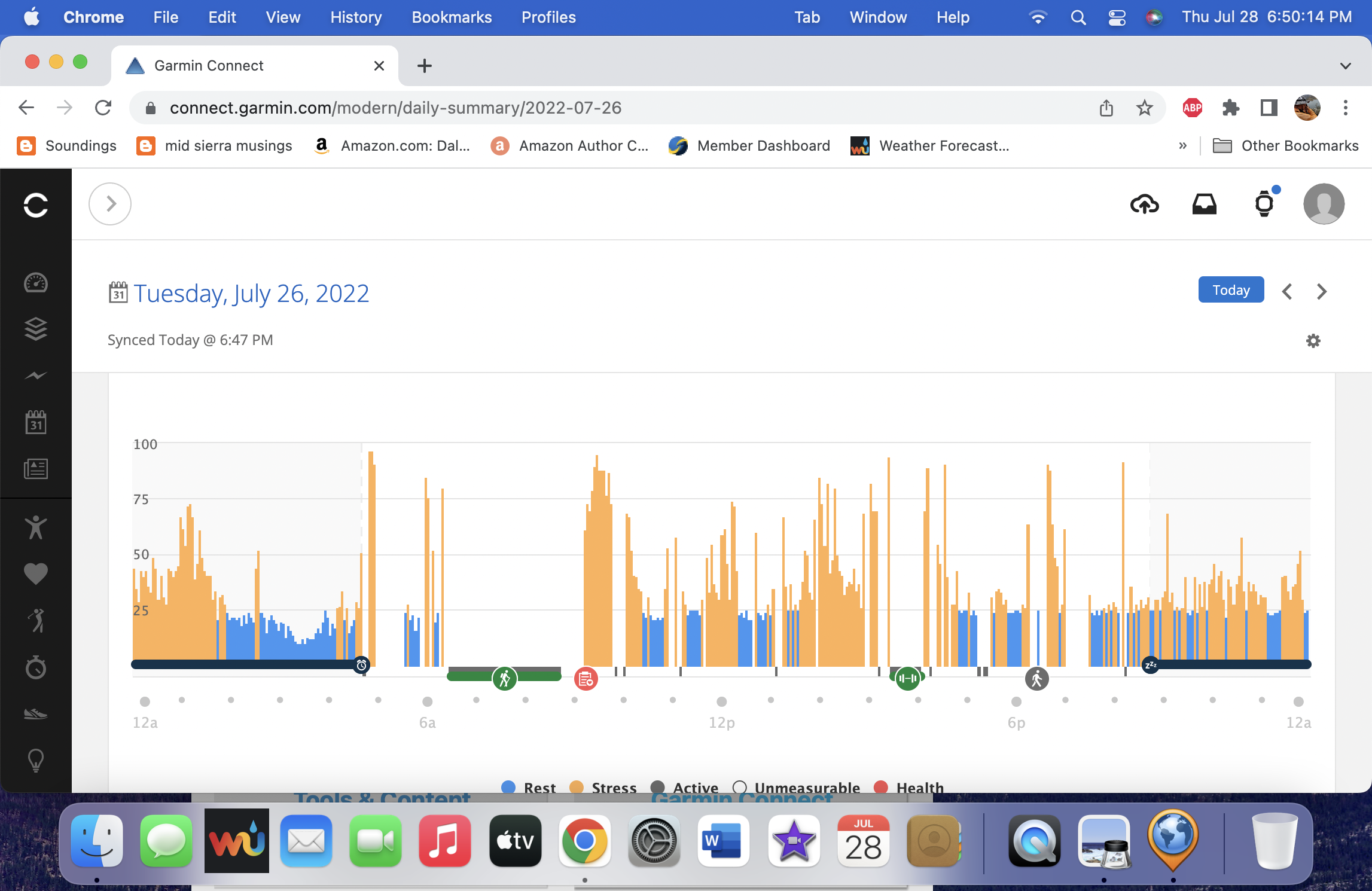
Click On Graphics To Enlarge

Garmin Fenix uses metrics that don’t just examine the length, depth and quality of sleep. When combined with a stress score that is recorded during the day and during sleep, it shows up as a “Body Battery” score that you begin with each day. Sleep is an important variable in overall health. When stress interferes with sleep, it can contribute to major health problems. https://psychcentral.com/stress/is-stress-the-number-one-killer

When I do a lengthy difficult hike in the mountains, my body battery could be as low as 5 (out of 100) at the end of the day. When I do a hike of that magnitude, it also means that I may have up to 72 hours of recovery or more. That does not mean that I don’t exercise the following day but complete rest would speed up recovery.

During sleep, there is some recovery so that I don’t start the following morning with a body battery of 5 even with a poor night’s sleep. However, If I look at my stress score during sleep based primarily on HRV (Heart Rate Variability), There are some nights that show high stress even during deep sleep. 

I realize that as an older person, I no longer get the quality of sleep that I did as a young person. Additionally, Drinking can also have an effect on the quality of sleep. I don’t drink however. I don’t have sleep apnea, finish eating more than three hours before bed time, and have a BMI of 22. I am retired and have no stressors that I am aware of. So why is my sleep so often stressed? Why do I awaken in the morning with brain fog and fatigue even when I have a recorded sleep time over 8 hours?

What I share with so many folks is PSTD. I have suffered many traumatic events throughout my life. I believe there is a hyper-vigilance that is now “on duty” 24/7. There is a wealth of research about this topic. For example, https://www.ncbi.nlm.nih.gov/pmc/articles/PMC4197954/

I thought I would show a couple of charts from a couple of nights sleep that typify what I have been saying.


    While the final screen capture is fairly normal, my stress during sleep is more akin to the first two examples. While I think avoiding caffeine entirely would help and having an ordered/structured day would help, I think at St. Paul would say, "Finally, brothers and sisters, whatever is true, whatever is noble, whatever is right, whatever is pure, whatever is lovely, whatever is admirable—if anything is excellent or praiseworthy—think about such things." (Philippians 4:8)


Saturday, July 23, 2022

Day Hike To Mount Givens 2022

Day Hike To Mount Givens 2022

Dale Matson

Click On Photographs To Enlarge


I have done this hike several times. The particulars are contained in a previous post. https://midsierramusing.blogspot.com/2014/07/day-hike-to-mt-givens-from-white-bark.html

My son Ben and I set out from Fresno at 6am, which got us to the trailhead at 8am. Our hike took about 4.5 hours round trip with about 2,000’ of gain and a distance of about 5.6 miles total. We began the hike as usual on the 33-mile Dusy Ershim OHV trail. This trail travels to Courtright reservoir and is only for the most rugged vehicles. https://www.youtube.com/watch?v=23y78UkIqfs

In more recent years I have discovered a cut-off trail which is more shaded and direct. Yesterday was hot, even above 10,000’.

Ben ran into a work colleague who was traveling the trail below us and was waiting for another Jeeper to get unstuck.

As you can see by the GPS overlay on the topo map, our final ascent off trail was too direct and made for steep travel. When we were inbound, we took a more forgiving route downhill.

I left my trekking poles leaning against a tree before scrambling up the last boulder field toward the radio antenna at the top. It is a 360-degree view that begins in Yosemite and runs south below Mt. Whitney. I used the “Peak Finder app on my iPhone and it labels some of the mountains fairly accurately. I have included some of the Peak Finder shots. The air was fairly clear.

The inbound trek was hot for me and I needed to rest a couple of times in the shade. There is no water on this hike, so bring at least 2-3 liters with you. No bugs.

This year I used my Sony A7C with the Sony 85mm 1.8 lens for photos and for video.  


Wednesday, July 20, 2022

Nellie Lake Hike 2022

Nellie Lake 2022
Dale Matson

Click Photographs To Enlarge


8.4 miles round trip with 2,000’ of total gain. I took about 5 ½ hours round trip. Maximum elevation is around 9,000’ “All Trails” rates this as a “hard” hike yet George Lake, which is about 10 miles and the same elevation gain is rated as “Medium”? At age 77, I would rate them both as “hard”.

This was my first trip to Nellie Lake following the devastating Creek Fire. The Creek Fire is the largest single wildfire ever in CA. Much of the Sierra National Forest was destroyed from Cressman Road N.E. to Huntington Lake and Big Creek. The Nellie Lake trail was closed for a considerable amount of time because of safety concerns. 
    The first two miles outbound had only dead and charred standing trees. It remains to be seen whether the U.S. Forest Service will allow the trail to remain open unless they do extensive cutting along the trail. Part of the problem is that the trail is in the Kaiser Wilderness and there is nothing but hand tools allowed in a wilderness area. The longer the dead trees stand, the more likely they are to fall.
    Much of the signage was burned up also and where the trail meets the Mary’s Meadow trail is no longer signed and almost invisible. Outbound, I needed my GPS to get me back on the trail when I lost the proper route. (In bound I was able to stay on the trail)
The trail was even dustier than usual with powder mixed with charcoal. Once past the burn area, it was business as usual and a well-defined trail. The Sierra National Forest Workers were working on the deadfalls the day I made the hike. I didn’t run into Ray Acker. His fellow workers said he retired but still volunteers. He and I used to duke it out at C.C. ski races. 
    I saw bear scat and three deer as I hiked. There are also lots of cattle tracks. Ranchers lease the land to feed their cattle. The final part of the trail outbound drops down to the lake. The trail begins with a steep ascent, flattens out with some rollers and then there is a 2nd steep ascent before it drops down to the lake.
    There are two spots where the trail currently crosses streams for filtered water resupply but these streams are seasonal and will dry up later. You can obviously resupply at Nellie Lake. If you pack all your water, I would recommend at least 3 liters. Also bring insect repellent. I only saw one other person on the trail which is common for weekdays. There are camping spots around the lake that can be reserved.
    Was it worth it? Yes, Nellie Lake is a peaceful place with a gentle wind most of the time. I got an early start and was back to my truck by 1pm. I would recommend an early start. It was 80 degrees at 1pm at about 7,200’.