Dale Matson
Click on photographs for a larger view
Perhaps the hardest part of getting to Center Basin is
finding the junction where it departs from the John Muir Trail. The Center
Basin trail travels along the eastern side of Center Peak and the JMT travels
along the western side. The route to Center Basin and Golden Bear Lake from
Onion Valley is definitely not the shortest but the route into Center Basin
past Robinson Lake over University Pass is mostly off trail and I was by
myself. The Onion Valley route round trip is about 33 miles with about 7,600’
of altitude gain overall. One of the most discouraging locations on the JMT is
where the Bubb’s Creek Trail joins the JMT. From that point it is climb, climb,
climb heading north or south. You could also do this from Road’s End but after
several trips ascending the Bubb’s creek trail I would rather drive to the east
side and climb over Kearsarge Pass.
Heart Lake
Big Pothole Lake
Kearsarge Lakes And Pinnacles
Bullfrog Lake In Distance
Bullfrog Lake
The Kearsarge Pass trail is about the most merciful ascent
you will find from east to west over the Sierras. The trailhead is above 9,000’
and the trail itself is well maintained and gradual. There are several lakes
along the way but resupply water before Heart
Lake. The pass has a wonderful view to the east that includes the Pinnacles,
Kearsarge Lakes and Bullfrog Lake. Bullfrog Lake has been closed to camping for
many years because of overuse.
Center Peak In Center And East Vidette On Right
Bubbs Creek
Approaching Center Peak
Junction Peak In Distance
Center Basin Crags
This is the first time I had taken the trail past Kearsarge
and Bullfrog Lakes to join the JMT to head south. You descend from the junction
another 1,000’ until the junction with the Bubb’s Creek Trail then begin
climbing again heading toward Forester Pass.
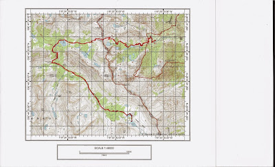
Map Route Versus Actual Trail Into Center Basin
Center Basin
Campsite By Center Peak
Golden Bear Lake
Sunrise At Center Basin Crags
Center Basin Junction Markings
Flower Lake
Kearsarge In The Afternoon Light On The Return
Bullfrog Lake Panorama
Here are some hints at where the Junction with the Center
Basin Trail can be located. My GPS (NAD 27) gave the location as N 36°44.054’ W
118° 22.474’. The altitude was 10,474’. About 20’ south of the junction is a
use trail leading west and down to an established campsite with a bear box near
Bubb’s Creek. If you come to this trail, you have already passed the junction
on the east side of the trail between two trees marked with Cairns at the foot
of both trees (See included photographs).
There is a caveat to maps when the maps note that a particular trail is an approximate location. I found the trail to Center Basin sketchy at times but not hard to follow if you pay attention. When I downloaded my route, it was more direct to the first two lakes than the map indicated. Yes, there is a marshy area before reaching Golden Bear Lake but I lost the trail skirting the marsh and took a more direct route. It rests on an obvious ledge about 40’ above the two smaller lakes.
Was the trip worth the effort? Yes, if I had it to do over
again, I would spend an additional night in Center Basin, follow the trail
south as a day hike and return to the first lake for the final night.
Note: It took me just over four hours to get to Lone Pine from Fresno going over Tehachapi. It took me over five hours returning to Fresno over Tioga Pass through Yosemite. Both routes are about 260 miles.
Note II: There is a YouTube video of this with additional graphics here:
https://www.youtube.com/watch?v=c0-AdgoNPU4&feature=youtu.be
Note II: There is a YouTube video of this with additional graphics here:
https://www.youtube.com/watch?v=c0-AdgoNPU4&feature=youtu.be


Note
ReplyDeleteThe original JMT route selected by Wilbur McClure the CA state engineer went through Center Basin, over Junction Pass and over Shepherd Pass until the Forester Pass section was completed in 1938. I assume McClure Meadow in Evolution Valley was named after him.
I see there a lots of page views on this trip. One suggestion would be to do it as a three night four day trip. Perhaps an overnight at Kearsarge Lakes, overnight at Center Basin and another overnight at Kearsarge Lakes on the return leg.
ReplyDeleteI was at the trail junction two days ago; it's just as your photo shows it to be. For those traveling southbound, the junction is right past a particularly scenic overlook of a meadow with Bubbs Creek meandering through.
ReplyDelete