Dale Matson
4 miles, total time
out 2:36, 285’ ascent
Click On Photographs To Enlarge
Route Drawn On Enlarged Portion Of Snowpark Map
GPS Download Of Route
Waypoints Indicate Trail Junctions
For background and directional information see a previous
posting on the Tamarack Snow Park here: http://midsierramusing.blogspot.com/2015/11/tamarack-ski-2015.html
The conditions were too icy for skis since we are still
awaiting another snowfall but the trails have thawed and refrozen and been
packed by snowmobiles on the Tamarack side of Highway 168. Because of this,
while I did take my snowshoes and trekking poles, I opted to just walk the loop
trail in my insulated boots. There are many new trail markers on the trees,
which really helps one to navigate.
As Susie and I were getting ready to head out from the
trailhead, we talked a bit with Tony and his coworker who were headed out on a
track machine to remove downed trees from the trails.
There were places on the trail where the snow had completely
melted but Susie was quickly in snow up to her belly off trail.
It was a pleasant 45-degree day and I did not use a hat or
gloves. After about 1.5 hours, I saw a large rock with no snow to sit on. I sat
down not because I had to but because I wanted to. Susie sat with me and we
shared an energy bar. After about 10 minutes, she jumped up and started
barking. I have no idea why but it is nice to know that she is both a companion
and a sentinel.
The final photograph is a derelict lookout tower on Bald Mountain (7,830'). One of the trails (Bald Mountain Trail) from Tamarack leads to Bald Mountain and I skied it a few years ago. Bald Mountain is about 7 miles from the trailhead at the Tamarack Snow Park. The lookout tower can also be seen from the SoCal Edison picnic/parking area on Shaver Lake and also from Dinkey Creek Road.
Tony And Coworker Outbound For Chainsaw Work
Red Mountain (9750') With 400mm lens
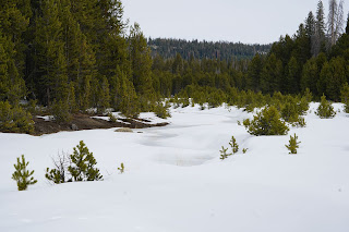
Tamarack Meadow
Tamarack Creek
Bald Mountain Lookout Photographed From Highway 168


No comments:
Post a Comment