Sequoia Park: Alta Peak Trail Day Hike
Dale Matson
Click On Photographs To Enlarge
Hike Route
I hiked to Pear Lake a couple of times on the Lakes Trail
out of Wolverton. http://midsierramusing.blogspot.com/2014/08/pear-lake-as-day-hike.html
The trail to Alta
Peak begins at the same place and the two trails depart from one another 1.8
miles from the trailhead. You can find the entire hike to Alta Peak here: http://midsierramusing.blogspot.com/2014/08/day-hike-to-alta-peak.html
This day I hiked about 6 hours on the trail toward Alta Peak
and covered about 10.5 miles round trip with about 2,000’ of gain outbound.
Plan on a dry hike, few bugs, and a good trail with a civilized grade.
The junctions were well marked with poor air quality and few
other hikers. For those who want a shorter hike ending with an unobstructed
view, I recommend they go as far as Panther Gap, which is about 3 miles from
the trailhead and about 1,200’ of climb. Until that point, the trail will be in
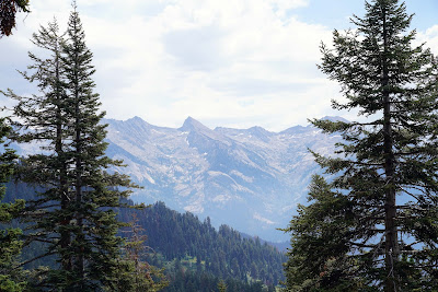
the trees. From there one can see the Great Western Divide, which separates the
Kings, Kaweah and Kern River drainages. About a mile further on the Alta Peak
Trail there is a spur trail near Mehrten Meadow that joins the High Sierra
Trail that crosses the divide at the Kaweah Gap. It later joins the JMT to Mt.
Whitney.
I used my Sony A7R2 with the Sony 24-70 2.8 GM lens.
Trail Markings In The Trees For Winter Travel
Still Some Water
Trail Sign Just Below Panther Gap
Great Western Divide
Mehrten Meadow Campsites Available Here
There Are Campsites Available At Alta Meadow
Is This Tharp Rock From Below?
Or Is This Tharp Rock From Below?
Clear Zoom Of 70mm (140mm digital zoom)
Black Kaweah Far Left


No comments:
Post a Comment