Dale Matson
Click On Photographs To Enlarge
I have a prior posting on this hike from 2014 here: http://midsierramusing.blogspot.com/2014/07/day-hike-to-mt-givens-from-white-bark.html
So why am I posting another hike to Mt. Givens?
1.
I have different camera lenses this time around
and…
2.
I want to talk a bit about off trail navigation
required by this hike.
Lenses
Last time (2014) I used a 35mm f2.8 Zeiss lens with my Sony
A7 and a Sony Point and shoot, 30X zoom for the photographs. This time I used
an adapted Canon 17-40mm f4, a Zeiss 55mm f1.8 and the Sony G 70-200mm f4 lens.
Unfortunately, there was considerable smoke from fires to the north and the
“Rough Fire” to the south in Kings Canyon. There is an obvious smoke layer in
some of the photographs.
I was happy with the Zeiss 55mm lens BUT it is possible to
get blurry shots hand held even with a lens this fast. I took a 55mm shot of
Mt. Givens from White bark and was able to blow it up big enough to make out
the radio antenna on top. I have ordered the A7RII, which has in body image stabilization,
which will bring out the full potential of this lens.
I continue to be happy with the Canon Lens, which I bought
used. I don't see myself replacing it with the Sony Zeiss 16-35mm lens
especially since I will soon have image stabilization for that lens with the
new camera. The Canon lens has autofocus with the Sony through the adapter.
The 70-200 lens is heavy to carry on the mountain trails and
sometimes I wonder if it is worth the bother carrying it with me. The results
are spotty with some great shots and others that are not sharp at all. Yes, I
know that even with optical steady shot (OSS) I should be using a tripod with this
lens. The tripod is another heavy item on mountain trails. Other than wildlife,
I think it may be better to go with the new Zeiss Batis 85mm 1.8 in the
mountains. It is lighter and smaller. I'll keep the 70-200mm lens for places I
can drive to.
Navigation
If you notice on the map, the last half mile outbound is an
off trail climb. There are assorted Cairns which tend to disappear about half
way up. I set some waypoints beginning with my truck. My second waypoint was
where I followed a more direct use trail, which led off the main Dusy Ershim
trail. Eventually this trail comes back to the Dusy Ershim Trail before the off
trail climb begins. There is a cairn at this location to mark where the climb
departs from the main trail. I set another waypoint at this spot and about half
way up the climb. The Garmin Oregon GPS allowed me to select Mt. Givens as a
“Go To” location and it helped me pick the most direct route when I selected
the electronic compass. My climb off trail was fairly direct.
Once I decided to
leave Mt. Givens, I selected my mid climb waypoint and again selected the
electronic compass which continually monitored the direction of my descent. As
you can see, I hit the exact spot midway down the descent and the alarm rang to
inform me of that fact. As I continued to descend, you can see I drifted pretty
far off my outbound trail to the east. At some point I remember being almost
500’ off course to the east for the next waypoint. I eventually headed west far
enough to hit that waypoint also (The spot by the cairn). What I had failed to
do outbound was set a waypoint where the use trail rejoined the Dusy Ershim
Trail. I couldn’t find this spot inbound and had to stay on the longer, rockier
and dustier main trail.
I know some of you folks have an excellent sense about where
you are but I have to rely on instruments. In fact, I wear “a belt and
suspenders” by carrying a compass also. My Suunto watch also has “track back”
and “find back” features. I noticed the photo of my Ambit shows the altitude
about 100’ less than the actual altitude of Mt. Givens. The overall distance on
the Ambit was about a mile less than my Garmin Oregon also. I have a word of
caution about the Oregon however. After resetting the trip distance and routes
prior to heading out on a new hike, recheck the trip computer a couple of
hundred yards down the trail. Sometime my GPS adds the driving distance from my
home and averages the speed too!
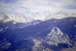
The Photographs are from 17mm to 200mm
Edison Lake In Center
33 Miles Of Hell To Courtright Reservoir
I would Rather Walk Than Drive This
Deer Lake In Front With Huntington Lake In Background
Free Range Cattle I Saw Tracks Almost To The Top Of Mt. Givens
Cairn Marking Where Climb Depart Main Trail
First Sight Of Radio Tower
Locator Spotting Scope On Top Of Mt. Givens
Time Out/Distance/Altitude
Mt. Givens From Whitebark Vista
Trail name Padre


No comments:
Post a Comment