Dale Matson
Click On Photographs To Enlarge
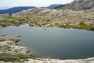
Moose Lake With Great Western Divide
I am often motivated to do a particular hike based on a
single photograph especially if it is mountains and water. Moose Lake became a
candidate for a visit last year after seeing a photograph and a day trip to
Pear Lake. I have been to Alta Peak and have seen Pear Lake below but I could
not see Moose Lake from Alta Peak (some folks go to Moose Lake from Alta
Meadow).
Why is it called “Moose Lake” when there have never been moose
in California? Perhaps it’s because as I look at the topographical maps (aerial
view), to me it looks like the head of a moose.
First, I must add these cautionary notes. I do not recommend
this off trail hike (about 7 miles round trip with about 2,000’ of total
elevation gain) to those who are not very fit and sound. I do not recommend
this hike to a person traveling alone. I do not recommend this trip to anyone
who has not navigated off trail. Off trail hiking is not different in degree
than on trail hiking. It is different in
kind. Lastly, I do not offer the route we took as the best route. It worked
for us but I only included it to show you where we went not where you should
go. Lay out your own best route
before you leave home. Our return leg on tired legs took a different route
than our outbound route and took us past more unnamed alpine lakes but through
more difficult terrain. Was it worth it? Yes.
In addition to the
companionship, depending on younger legs and better eyes, I saw Moose Lake in
front of one of the most magnificent mountain ranges close up. I saw the Great Western Divide from the Alta Peak trail but never with such a beautiful and large lake
in front of it. We also had a generally good air day for Sequoia Park. We could
see smoke from the “Cabin Fire” to the south. It had burned 4,000 acres at the
time we were there. Even my 17mm lens could not take in all there was in front
of me. I stayed a hundred feet above the lake to try and get it all in. This
was hiking in the mountains at its best.
Descending on tired legs back to Pear Lake (elevation
9,500’) was difficult. Think about a 7-mile trip that took 8 hours. We were
thankful that no one fell yet at times we were wearing out the seat of our
pants sliding down terrain too steep to down climb. To some, this would be a
simple hike. For me at age 70, it was one of my toughest hikes. I will never do
it again but am thankful for this wonderful experience. I was glad that we had
an additional night at Pear Lake to rest before heading back to our cars at
Wolverton.
Additionally, I have thought further about traveling off
trails and the potential negative impact on the alpine vegetation. We hiked on
granite whenever we could do so but I wonder if a maintained trail would
actually reduce impact on a specific area. It would definitely lead to more
traffic but would confine it in the long run. For those of you who are not able
to take this hike, I hope you will enjoy the photographs.
Suunto Ambit 2 Download To Movescount
First View Of Moose Lake
Carlos Pointing Out The View
Person On Top Of Alta Peak 200mm
The Final Climb On The Return Leg
Hiking A Short Use Trail
First View Of Great Western Divide
Moose Lake Panorama Black Kaweah Far Left
Unnamed Lake On Return Leg
Pear Lake On Descent Leg
Another Unnamed lake
Solitary Cairn
Lots Of Unnamed Lakes
Smoke From "Cabin Fire" Coming Over Center "V" Notch
Difficult Ups And Downs
Weather Station Near Unnamed Lake


No comments:
Post a Comment