Dale Matson
Click On Images To Enlarge
 Hike Route

If you are near the Mt. Whitney Visitors’ Center on Highway
395, you will see a zigzag road going higher and higher above you and wonder
where it goes. Well, It is the Horseshoe Meadows Road. The trailhead for this
hike is off the Mt. Whitney Portal road with a left turn onto Horseshoe Meadows
Road. There are informational signs, campsites and toilets at the trailhead.
Our hike was about 14 miles round trip with a starting elevation of about 10,000'.
As you can see by the topographical map GPS download, our outbound and inbound
routes were somewhat different.
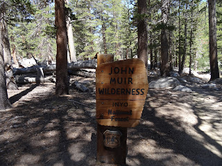
We hiked it on a weekday and saw few folks on the trail. The trail begins in the Golden Trout Wilderness but crosses into the John Muir Wilderness. There is about 1,000' of elevation gain. The Cottonwood Lakes Basin reminds me somewhat of Humphreys Basin with both basins being above 11,000’ in elevation and having one dominant mountain. In this case it is Mt. Langley, which is over 14,000’. I found there to be adequate water along the way for resupply. For those who are peak baggers, Mt. Langley has a class 2 route. There is a signed trail junction for the trail to Mt. Langley that goes over New Army Pass.
It took us about 7 hours walking at a casual pace to reach Lake 4 and return to the trailhead. I was hoping to see Bighorn Sheep but they were not to be found this day. This is the Langley herd unit area for the endangered Sierra Nevada Bighorn Sheep.
Much of the initial climb is in the woods and there is really
not much to see until you break out above tree line. After this the walk is a
gentle grade with expansive views. What I really appreciate is the high
elevation start at the trailhead, which makes this basin very accessible as a
day hike. There are no high passes to climb to get there. My brother in law
enjoyed catching (and releasing) some Golden Trout.
As an added bonus, we were there the day some of the folks
running the Badwater 135 Ultramarathon were turning the corner onto Highway 395
and heading toward the finish at Whitney Portal as we came down. I completed
the Western States 100 mile endurance run and that was difficult enough for me.
My best advice for those considering Badwater is….. don’t do it.


There is a YouTube video including video clips at the end here: https://www.youtube.com/watch?v=BIpAGXURB-c


Mt. Langley

There is a YouTube video including video clips at the end here: https://www.youtube.com/watch?v=BIpAGXURB-c
No comments:
Post a Comment