Dale Matson
Click On Photographs To Enlarge

Hike Route Ambit 2 Download To Movescount
This trail is 1.2 miles total out and back with 532’ of elevation gain outbound from the trailhead. This is a steep trail. To get there from the Fresno CA area, you take Highway 206 out of the town of Friant and drive over the bridge that crosses the San Joaquin River/Millerton dam outlet. You turn right at the stop sign and go around to the Madera side of Millerton Lake. There is an entrance to the lake and a fee pay booth. Continue driving untill you see the trailhead sign on the left and Buzzard’s Roost pull out on the right for picnicking. That is where I parked and crossed the road to the trailhead.
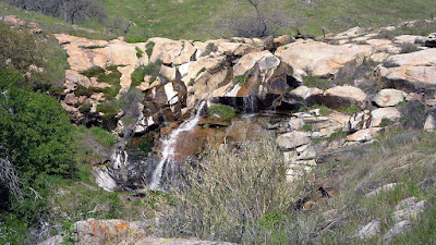
This is a good time of year for this hike while there are no mosquitos, cooler temperatures, and a lovely seasonal creek to your left with a waterfall as you ascend. There is a sign at the trailhead warning about poison oak. The best prevention is to know what it looks like, stay on the trail and to take a shower using “”Technu” skin scrub at home immediately when you return if you believe you came in contact. If so, immediately wash your hiking clothes also. Poison Oak generally does not grow above about 6,000’ but Buzzard’s Roost is only about 1,083’ in elevation.
If you want a good view of the main part of Millerton Lake and are fit enough to make the climb, this is one of the best spots. There were several buzzards and crows that circled above me as I climbed. I did not take it personally since the name of the location was not accidental.
Keep an eye out for eagles, hawks and Osprey who also like to ride the updrafts created by the cliffs surrounding the lake. The top is a great place for a lunch. From Buzzard’s Roost you can see the “Big Bend” section of the lake, Winchell Cove across the lake, Winchell Point, The ‘Glass House which sits out on a peninsula with it’s resident Bald Eagle nest. You can also see the snow covered mountains. You can see Pincushion Mountain (about 1,350’ in elevation). That is another nice perspective, which can be reached via the San Joaquin River Trail at the end of Sky Harbor Road on the Fresno County side of the lake off Millerton Road. Sky Harbor Road is located just before the Table Mountain Casino and requires a 6 mile drive to the Finegold day use area where it dead ends. The San Joaquin River Trail begins in the day area and is also a steep climb.
I used a Sony A7R2 with a Batis 85mm 1.8 and an Adapted Canon 400 f4


Much The Low Lake Area Is 'Draw Down' Anticipating Future Runoff

You Can See Sky Harbor Road Heading Down To Finegold Area


Lupin

Table Top The Original River Bed Elevation

Big Bend


Pincushion Mountain


"Glass House"

Boat Ramp On Madera Side With Camping And RV Slots


Buzzard's Roost From Below 400mm
 Buzzard's Roost From Across Millerton Lake At Winchell Point 400mm


No comments:
Post a Comment