Dale Matson
Click On Photographs To Enlarge
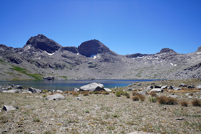
For years, I have been captivated by both Mount Goddard (13,653’) and Martha Lake. I have seen Mount Goddard from Evolution Basin and even as far away as the vista at Courtright Reservoir. I have seen videos of folks who have traveled to Mt. Goddard to climb it. There is one problem. Goddard Canyon in Kings Canyon National Park is very isolated. Martha Lake in nearly 25 miles from the nearest trail head.
I tried hiking there from the Maxson Trailhead a few years ago and gave up at Hell-For-Sure Pass above Goddard Canyon. I was set to go last year out of Florence lake using a packer from Muir Trail Ranch but I started having a problem with blood in my urine about four days before I was set to go.
I prefer the trail out of Florence Lake except for the long drive from Fresno. The last fourteen miles are on a single-track road and it takes an hour just for that part. The road out of Courtright Reservoir is more civilized.
After the ferry ride on Florence Lake, you may see a Mercedes Unimog parked on the far shore. It has its own route which crisscrosses the foot trail for about five miles until the private Muir Trail Ranch. My packer met me at the far shore and at the end, dropped off my pack near the ferry.
At this point, the trail can be quite busy since the JMT folks also use the section from the junction of Evolution Valley and Goddard Canyon. Those who are traveling north continue to Selden Pass near Muir Trail Ranch. There is a cut-off trail to the ranch for JMT folks to have food resupply there.
The trail into Goddard Canyon is seldom traveled but that is the source of the headwaters of the South Fork of the San Joaquin River at Martha Lake.
I worked out an arrangement with Hilary at Muir Trail Ranch for a packer that would accompany me and carry my pack on a mule. This way, this 75-year-old geezer could do the impossible. I would essentially be doing this 40-mile hike as a day hiker. The packer would have a horse and a mule. I would guess I hike a little less than 2 miles an hour so the packer being faster would wait at key junctions like the Piute Creek Bridge just before entering Kings Canyon. Then again at the JMT/Goddard Canyon junction. I did a lot of hiking the first day and we decided on a campsite just before “Pig Chute” in Goddard Canyon. This became our base camp for two nights since I hiked to Martha Lake the second day and we stayed the night there again. The third night I spent at Muir Trail Ranch.
I know there are plenty of folks who use packers but this was my first time and I believe this arrangement could extend my hiking goals to places I have yet to visit.
I used a Sony A7R4 and a Sony 16-35 2.8 GM lens


Hi Dale, we did that trail and stayed 2 weeks at Martha Lake when I worked for NPS Sequoia-Kings in 1992. I have a photo from 1992 of that same waterfall when water was MUCH higher, by about 20'. So nice to travel this route again through your eyes as I did not have a camera then to document the journey!
ReplyDeleteHi Stella,
ReplyDeleteYes, I was able to see Martha Lake the last two years. I imagine the water was much higher in 1992 and in 2017 also.
I was reading about the San Joaquin and became interested in its headwaters. Thank you for sharing this photo album!
ReplyDelete